Type:		Two masted wooden brig
Length:		77.8 ft.x 21.8 ft.x 7.7 ft., 112 gt.
Depth:	        20 - 35 ft.
LON/LAT:	47. 28' 34" / 87. 51' 88"
LORAN:		31725.4/46643.3
On September 21, 1844, the Astor had just finished unloading supplies consigned to the troops at nearby Fort Wilkins, when a change in wind direction prevented the brig from getting underway. A gale arose and caused the Astor to drag her anchor. She eventually blew up on the rocks near the Fort Wilkins dock where she remained throughout the winter despite Captain Benjamin Stannard's attempts to free her. All of her rigging and machinery were salvaged. The Astor's loss caused great hardships among the fledgling settlements rimming Lake Superior that winter.
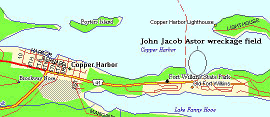
Today, the remains of the John Jacob Astor are completely broken up and scattered. They lie directly off the old Fort Wilkins dock. Divers can expect to find scattered pieces of the hull, timbers and other small structural remains. The ship's main anchor and ribs were brought up by divers in 1976 and can be visited at nearby Fort Wilkins State Park. Additional artifacts from the Astor are on display at the Copper Harbor Lighthouse Museum. The wrecksite can be visited from shore and usually has fair visibility from 20 to 40 ft. Despite the closeness to shore, the water is only about 40 - 45 degrees. An underwater "trail" has been mapped out to lead divers to widely scattered artifacts. The local diveshop can provide more information in this regard.
References: Keweenaw Shipwrecks by Fred Stonehouse, Shipwrecks off Keweenaw by Mac Frimodig, Julius F. Wolff Jr.'s Lake Superior Shipwrecks, Divers Guide to Michigan by Steve Harrington, Midwest Explorer's League: Lake Superior Dive Chart, The Long Ships Passing by Walter Havighurst, James Jackman.